Walk & Learn
Andrew Barton takes us on a walk around Longridge tracking the area’s quarrying and textile past. The route itself is quite short and the paths well surfaced so it is suitable for wheelchair users and prams. Photography: David Turner
Start: The Millennium Cross, Berry Lane
Distance: 1.5 miles (2.5km)
Time: 45 minutes
Terrain: Pavements and park paths
Longridge was first noted 500 years ago as a settlement around St Lawrence’s Church. The town has a rich industrial history and this walk will take you though some of Longridge’s oldest settlements and sites.
With the Millennium Cross on your left, travel up Berry Lane to the Post Office and continue along passing Irwell Street, Church Street and up to Market Place.
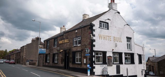
Turn left into Market Place and head towards the White Bull. The stone houses on either side of the road were built in the early 19th century and were occupied by hand weavers and nail makers.
Continue on at the junction along Higher Road, which was the original main road from Preston to Clitheroe.
Travel uphill passing a row of cottages on the right known as Club Row, which is made up of 20 houses built between 1794 and 1804 – they are apparently the world’s oldest surviving building society dwellings.
You will also pass Strickland House on the left and Broomhill on your right.
Continue along the road to the junction with Green Lane. The Cabin, which used to be a temperance saloon, will be to your left.
Go along Higher Road to arrive at Chaigley Road on your left. At this point on a clear day, you’ll be able to enjoy the view towards Blackpool.
Cross over into Ridge Court – if you look over the fence, to the left, you will see a tunnel used when the area was a quarry. Stone from these quarries was used in the construction of many buildings including the Harris Museum, Fulwood Barracks and Preston Train Station.
Travel back over the road to Chaigley Road, before turning right into John Smith’s Playing Field.
Evidence of the quarrying past can been seen around the park, with quarry tunnels, the quarry face and a cast iron crane base. When the original railway on this site was dismantled, this area was used as landfill and transformed into the park we see today.
Follow the path downhill to the left keeping the row of houses on your left, through the gates at the end of the park and left to rejoin Chaigley Road.
Turn right, then left at the bottom and right again to join Wheatley Drive. Continue passing Bowland Close and the Royal Mail Sorting Office on your right, turning right at the end of Wheatley Drive onto Green Lane.
Almost immediately, turn left onto Mersey Street and you will see the Co-operative Hall. Go straight along Mersey Street, turning right at the end to reach the beginning of the walk.
Courtesy of Lancashire Walks & Wildlife.
0845 834 1011
www.walksandwildlife.co.uk
www.facebook.com/walksandwildlife
www.twitter.com/wildlancs